@Jamespipe @Yusuf, I have been noticing that the “max” point clouds I am downloading are very reduced. I have noticed for a while that they may be “optimized”, but it does not seem right that a 126ac site that Pix4D produces 40m points for on medium settings should be 8m according to DroneDeploy… Is it of your opinion that this is true optimization and not affecting the accuracy?

Just ran the latest map in Pix4D… 

Hi Michael - are you processing in Structures or Terrain mode?
Structures will give you at least 4x points of Terrain.
Our testing shows we have a much cleaner point cloud than Pix4D in Structures mode. i.e. fewer points, but every point has at least 4 views, so they are particularly clean and accurate.
Let me know if you find otherwise and I will investigate for you with the computer vision team.
Many thanks,
James
Hi @Jamespipe! I typically process in terrain as that is my primary subject, but I am not clear on what structure mode would do to a civil model? Should I run everything in structure if I am interested in the most detail?
Good morning all! Just checking in on this. I know you were working towards denser point clouds, but I have not seen any increase yet. We are still at about half or two-thirds of what the Pix4D and Metashape medium settings clouds.
On average the point clouds for Terrain mode are 100points per sqm, while Structures mode are 550points per square meter.
If you fly a small building, at 100ft, you’ll likely get 1500-2500points per sqm. While it’s entirely possible to run our densify step longer, 99% of the time the generated data is not providing any useful value, aside from in visualisation.
RE: Michael - to your question, we are focussed on making our “structures” mode the one mode to rule them all, with the goal to remove the distinction between the modes by the end of Q1 for most users. There’s a way to go on that project, but the team is moving fast. I would recommend you start giving it a go, or compare the modes yourself. We’d love your feedback as always.
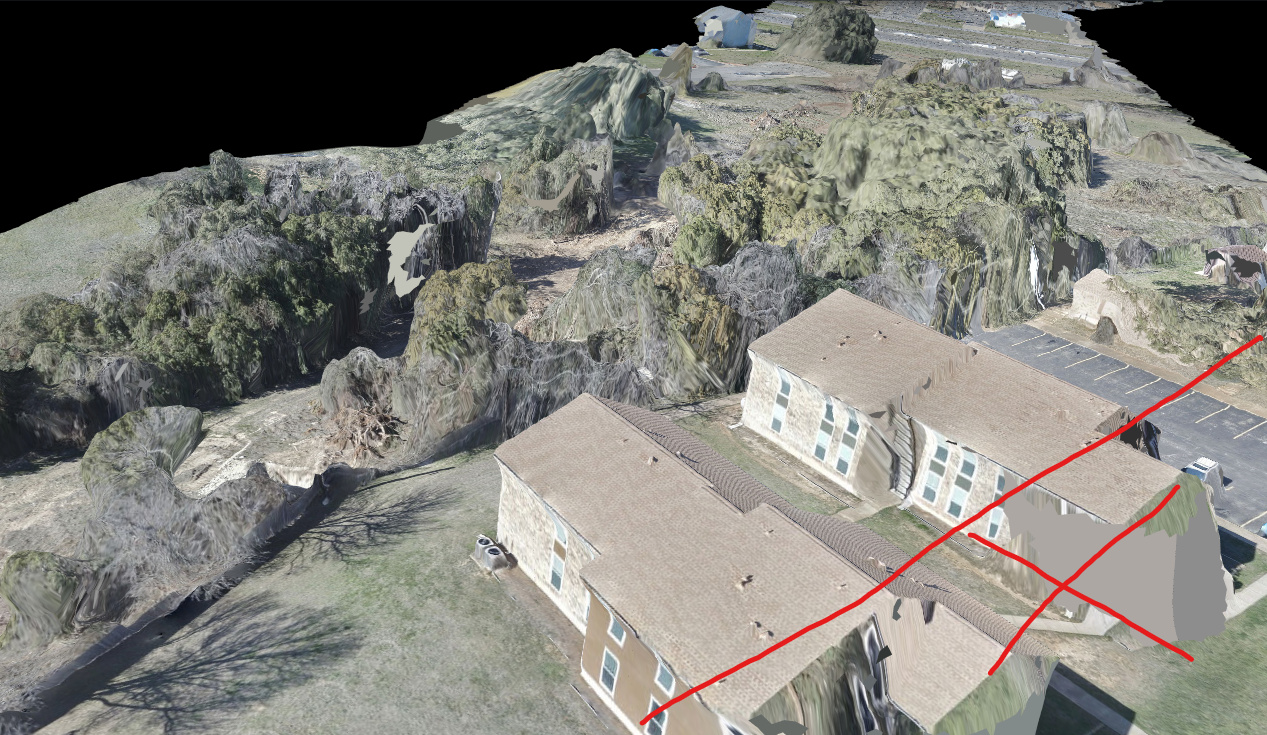
Thanks James. I quite often try both modes when processing a new job and agree that structure mode is improving, but the problem I have with it right now is that it is still cutting out data. Trees and finer detail around structures in particular.
The Structure mode reprocess test number one was a little better. Unfortunately I deleted the original map because it was so bad and processed the OBQ imagery in terrain mode. Another topic, but longer linear maps are still twisting without GCP’s. 19035 Northwest Blvd just finished and RBJ is processing.
Structure mode now looks like a hybrid with Terrain and there are a couple of small holes, but no entire patches taken out. No concern on the building as it is on the edge of the map and not part of the subject.