I’m new to using DD for figuring volume on stockpiles. Is there anything else to do besides selecting DTM for these particular piles to remove the conveyor from the calculation?
I’m new to using DD for figuring volume on stockpiles. Is there anything else to do besides selecting DTM for these particular piles to remove the conveyor from the calculation?
Carefully trace the pile and around the
edges of the conveyor to get a smaller estimate. Compare the 2 values. Are they close? If so the small error will be reduced further if you take the average of the 2 values.
Regards,
Terry.
If you trace around the conveyor the does it cut out the part of the pile underneath?
In the (?) section of the Surface selection it says…
“To exclude conveyors, bulldozers or other equipment from volume measurement, select the Digital Terrain Model (DTM)”
I haven’t found anything in the tutorials about measuring with and then around the conveyor and then averaging between the two values. If you do that you cut out all of the pile underneath the conveyor to the base plane, and leaving it in counts the airspace between the conveyor and the pile as volume.
I am just looking for some confirmation that using the DTM feature this will accurately measure the pile below the conveyor. Or is there anything else required.
Yes, if you trace around the conveyor then that part of the pile under the conveyor will be left out of the volume measurement. This will give a slightly smaller number. With the conveyor included you get a volume that is too big due to the conveyor being higher than the pile. When you average the two it is like including half of what is under the conveyor. This may be a little bigger than the actual pile but not by much since the error is on only a small fraction of the total. Try this and report back with the numbers.
You can try the DTM also and see how that compares.
Regards,
Terry.
What @SolarBarn suggests is the best way to handle this if you do not have point cloud editing software. I use Carlson Precision 3D Topo to remove vertical elements that do not need to be in the calculations. It will remove the conveyor completely and stitch the mesh across the missing points.
@SolarBarn @MichaelL
I tried what you guys suggested and here’s what I got…
482.5 yd/3 using DSM only and just tracing around the pile
57.2 yd/3 using DSM and tracing around the conveyor
76.1 yd/3 using DTM and tracing around the conveyor
130.9 yd/3 using DTM only and just tracing around the pile
The last calculation in the list is very comparable to other piles on the property of similar size that are free standing with no conveyors over them.
I have emailed my DD contact about this, but haven’t heard a reply yet. I’m a few hours ahead so they are probably not in the office yet this morning. When I get an explaination from them I’ll make sure post here.
I appreciate you both for responding and helping me out with this.
Those piles look like they are in the 1000cy range in comparison to the conveyor. I would not use the DroneDeploy DTM. It is not there yet. I would then use the distance (linear) measurement tool to look at the cross-sections and calculate from there to check.
What base plane did you use?
Baseplane used is Linear fit.
DD emailed back and said I need to select my industry to mining so the map is processed correctly for using DTMs on the conveyor piles. No mention of other apps or anything else to remove the conveyors.
Linear fit should be okay, but I almost always use triangulated to account for any irregularities in the ground or in the slope of the stockpile. That’s news to me that selecting different industries as different effects on the processing. It is something that needs to be shared with the public. @Kaitlin Especially since the construction industry has a lot of the same operations that mining does when it comes to materials.
DroneDeploy is not going to recommend any third-party solutions that they are not familiar with as they are focused on their own software. Would it be possible for you to share your point cloud. Make sure to download the max points.
Like Michael said, if you could share your point model then we could look into some of the details for you. Also having the .obj file would be nice. You could post a link to your files here or in a PM to us.
Regards,
Terry.
@MichaelL @SolarBarn
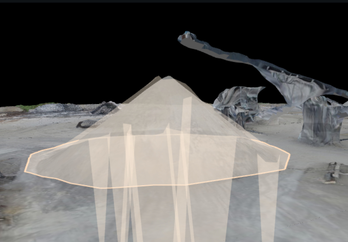
Sorry guys. I’m not sure what or where the .obj file is. I selected point cloud and attached the screenshot.
Area is 3,386 ft2
Volume is 817.2 yd3 using DSM and 763.6 yd3 using DTM
From what I understand when you show mining as your industry in your profile the 3D map is processed to eliminate objects like the conveyor when you select DTM as your surface. To figure the volume you draw your polygon like normal and select DTM for your surface. DD does the rest of the magic to figure the stockpile volume. I’m told that this feature has only been available for a few months.
This may be all for nothing anyway, at least for me. I found out yesterday the customer is not interested (yet) in figuring the piles under the conveyor. They weigh these on the truck on their way out when it sells so they are getting accurate data for what is sold. I guess they’re not as worried about this particular inventory.
I still want to learn and know how to figure it when the time comes, or for a different customer.
Again, I appreciate your responses and feedback for this rookie. 
Point Cloud Screen Shot
3D Map Screenshot
What plan are you on? It should be one above the point cloud in exports. It called model.
I definitely need to look into this because the DTM process in Construction is insuffcient. Can you show the color elevation map for each? It is pretty good at removing machines, cars and small trees, but that’s about it.
This is actually a big benefit to use especially when we are importing material from pits. They can say whatever they want about per truck and weighing, but the material on the ground is what counts. We have spotted under-quantity trucks many times. Of course in this case it would be in their favor.