We are investigating using photos from a variety of sources to generate a better 3D model. We’re wanting to make sure any photos have the correct EXIF data so it can accurately stitch everything together. My biggest concern is with the altitude. One set of photos from a DJI Phantom (both the 3 and 4 look the same) has the following in the EXIF data:
When looking at these in the camera roll after generating the map, it shows something like 4800 ft. It shows the absolute altitude from sea level, and not from the ground. It also looks like doesn’t use these photos in generating the 3D model (possibly because it thinks they were taken from 4,000 ft higher than the others?).
So, I’d just like to know if there are other tags in the EXIF data that are being used to generate the 3D model that the 2nd set of pictures just don’t have. We’re thinking we need to manually set some EXIF data for these pictures so they can be stitched with the others, but we’re just not sure what EXIF data that would be.
You’re correct, the DJI phantom 3 / 4 images have both the altitude relative to ground and relative to sea level embedded in the exif data, however most other drones will only have one of these.
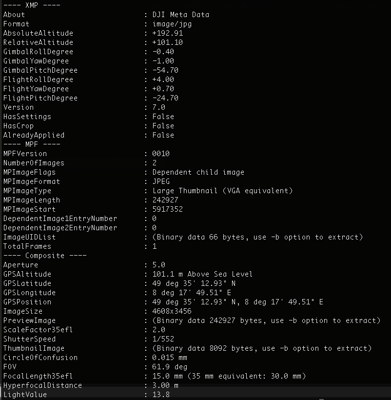
There are a number of tools available for viewing (and writing) all the exif data embedded in an image; the one I use is exiftool, which shows the extra data DJI embeds along with the standard info (this is only part of the output):
Mixing both imagery sets together may well cause some issues as the stitching algorithm is trying to match images with a 4000’ alt difference! What I would suggest is to replace the standard altitude (above sea level) values in your secondary image set with the above ground level values (if you have them). Another option would be to embed the AGL data in the same place as DJI does, so it would be automatically read in by our software (it’s in the “XMP” subsection of the exif metadata - see my screenshot for the correct naming convention).
Out of interest, what secondary source for the imagery?
I am trying to figure out what exact EXIF tags Map Engine requires for image processing. I am using EXIF version 2.3. Is it just GPS Lat, Lon, Alt and orientation or do you require more than that?
Hi, I am having exactly the same question (what exact EXIF tags Map Engine requires for image processing) but the link provided is dead. Can you please help me? I have a number of images without EXIF tags and would like to add to at least 5 of them the necessary data so I can create a mosaic.
In order to use Map Engine, your data must meet the following requirements:
All images should be in JPG format
All images must have latitude, longitude, and altitude in the GPS EXIF data
All images should be facing the area of interest (rather than off on the horizon)
All images should have significant overlap (more than 60% side and frontlap, 75% for agricultural or homogeneous imagery)
There must be at least 10 images. The maximum number of images changes according to your DroneDeploy plan.
We need to know what EXACT and SPECIFIC EXIF data DD needs to process vertical 3D models, the oblique camera our user used is a random generic camera and has no EXIF data save for the standard camera image data, we need to add the location, altitude etc, but we don’t know what else is required, the actual camera is a Sony LCE-5100, the DJI images contain the gimbal angle information but im not sure if adding the angle in the same field will yield the same results in DD