I collect data on the same sites for comparison month to month. I use the same GCP’s every month, and they are checked/re-painted every month prior to flight. The DD native heat map’s and elevation check’s all appear to be correct, but when exporting dxf’s to share with client’s there are large area’s of inconsistency.
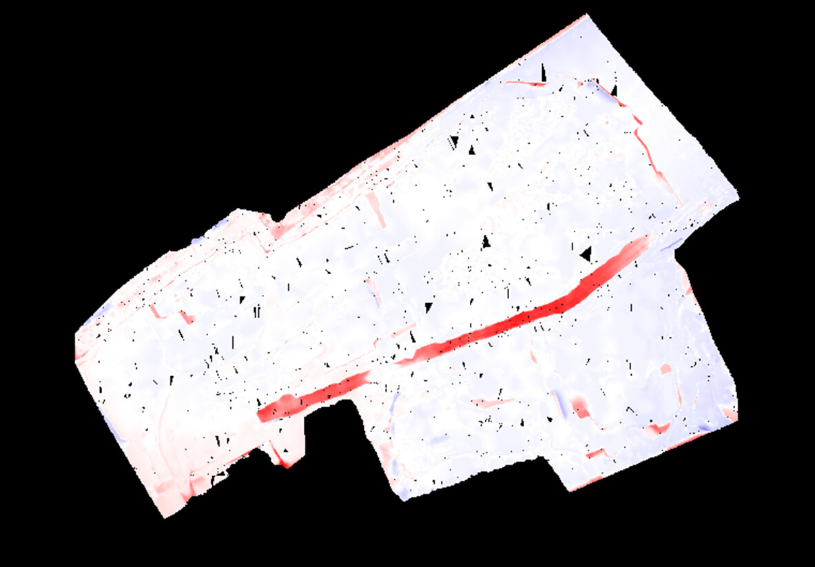
This is a C/F Heat Map generated from the dxf files comparing one month to the next. There are small area’s of change that are expected, but the big swath of red down the middle has remained the same and should not reflect a change.
Another strange thing is that when I use the contourshp files in a GIS software the contours are again very different and do not reflect credible elevations in some of the same key area’s. They also do not match the dxf.
This problem is not limited to just that area either. There are small area’s all over the map that when studied closely should not be as different as they are.
What steps can be taken to mitigate the inconsistency in these dxf files? Generally dxf info is shared at 5ft increment’s. Would a 2ft or 1ft be more consistent?
Have you tried using DSM contours?
I found that DD’s automatic DTM filtering is not always consistent between maps.
There are a few things I have done to get better DTM filtering results.
A time consuming method is to export DSM surface model contours and manually delete some of the unwanted object. I only do this on very small sites
Try Pix4d Survey. I found that this software is really good at filtering terrain. Of course this bit of software cost extra money, but for me it is essential to be able to manually filter the terrain for my landfill monitoring jobs.
I also use 12d / Autocad / QGIS for extracting contours out of GeoTiff’s
The only processing software I have gotten reliable and true DTM’s out of is SimActive Correlator and unfortunately DD’s are totally unreliable. The filtering values being used just aren’t there so you get things remaining that obviously should have been gone and other things getting annihilated that should have remained. The others either take forever or there filtering is very inflexible. We use an actual point cloud editing software to create our DTM’s so we just download the standard (DSM) point cloud. There’s still no replacement for having been on the ground and taking notes if you are collecting and analyzing the data.
Your correct DD’s filtering is not ideal. Although I found that using the same GCP’s every time I have had fairly consistent results for both DSM’s and ortho-mosaics. (within 50mm xyz with 1.5 to 2cm GSD resolution). If I need more accuracy or absolute certainty I will always go and complete a conventional ground survey.
I used to process with Pix4d Mapper but a 1000 photo data set would take somewhere around 15 to 24h to complete (desktop computer). Then I had to manually filter the point cloud to get a decent DTM. That would take hours of manual editing…
Now I am processing with DD and editing with pix4d Survey using their AI workflow. I can reduce the 10 mil point cloud down to 100’000 to 150’000 meaningful points on about 1 hour of work. I can have a 24h or less turn around for a large DTM.
I will check out SimActive, and see how they get the job done.
I agree, the DSM’s are great and process so much faster than local. It’s also good to hear others starting to trend towards 3rd party point cloud editing. It really does help to have a true cloud editor to maintain our 0.15ft tolerances.
One issue this poses are discrepancies when sharing the data with clients, as the levels may not be consistent with data downloaded from the web browser and the the paper and electronic plans. I usually end up with a list of disclaimers and accuracy statements on the distributed plans and emails…
There is also still a lot of work to be done explaining benefits and limitations to clients especially in slow moving organizations such as local government.
It depends on what plan you are on. You can do the single point vertical adjustment in the DroneDeploy interface as well if needed. We’ll do this after calc’ing the RMSE error and averages across the checkpoints but we are using RTK. You don’t have to do this with GCP’s which is nice but you also lose 1-2cm of accuracy unless you put down enough to cover the site on at least a 50ft grid plus grade breaks.
Always think about the big picture and the diversity of a drone. When you meet with clients look out for other things outside of mapping that you can do for them.
We can’t use DroneDeploy’s DTMs in construction. It is unable to tell the difference between large stockpiles and ground as well as large clumps of trees. This is why we make our own DTMs outside of DroneDeploy.